

- Joined
- Nov 2, 2025
- Messages
- 282
- Reaction score
- 0
- Points
- 16
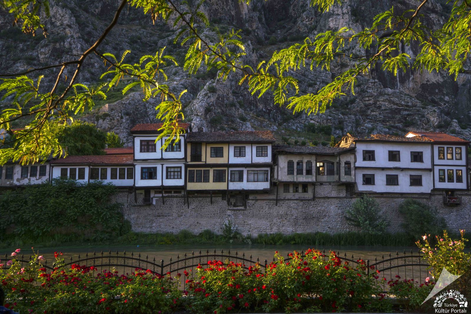
Historic Yalıboyu houses on the banks of the Yeşilırmak in Amasya.
Amasya lies inland in the central Black Sea region, its distinctive townscape set in a valley where the Yeşilırmak runs between steep rocky slopes. Historic buildings line the water, with royal tombs and the castle rising above. This relationship between river, mountain and home sets Amasya apart from coastal cities. It explains the concentration of old neighbourhoods beneath Harşena and the spread of modern development into the wider parts of the valley.
 The River and the Shape of the City
The Yeşilırmak forms a clear axis through Amasya. Houses, neighbourhoods and public buildings face one another across its banks, with bridges connecting parts of the centre. The water is both a geographical and an urban feature: following its course helps explain the distribution of buildings and the centre's relationship to the surrounding slopes. Agricultural plains and villages elsewhere in the basin connect the historic city with a productive countryside.
Amasya lies between Samsun, Tokat, Çorum and Yozgat, reflecting its transitional position between the Black Sea region and inland Anatolia. Rocky slopes, valleys and agricultural land are fundamental to its character, alongside a landscape distinct from coastal forests. Apples form a familiar part of its agricultural identity, within a wider range of produce grown in the plains and orchards.
 The Yalıboyu Houses
The Yalıboyu houses line the river above sections of the historic walls, with timber frames, earthen infill and tiled roofs. Their adjoining façades create a continuous streetscape, with enclosed bays and projecting upper floors facing the water. The buildings show how homes made use of limited space, combining riverside living, private interiors and windows opening onto the surrounding landscape.
Behind the façades are courtyards and rooms arranged around an internal space, with built-in cupboards, hearths and traditional seating. Their value extends beyond their outward appearance: they record the organisation of family life in an Ottoman city. The architecture connects with the lanes of Hatuniye neighbourhood and the urban fabric beneath the mountain, revealing the direct relationship between homes and terrain.
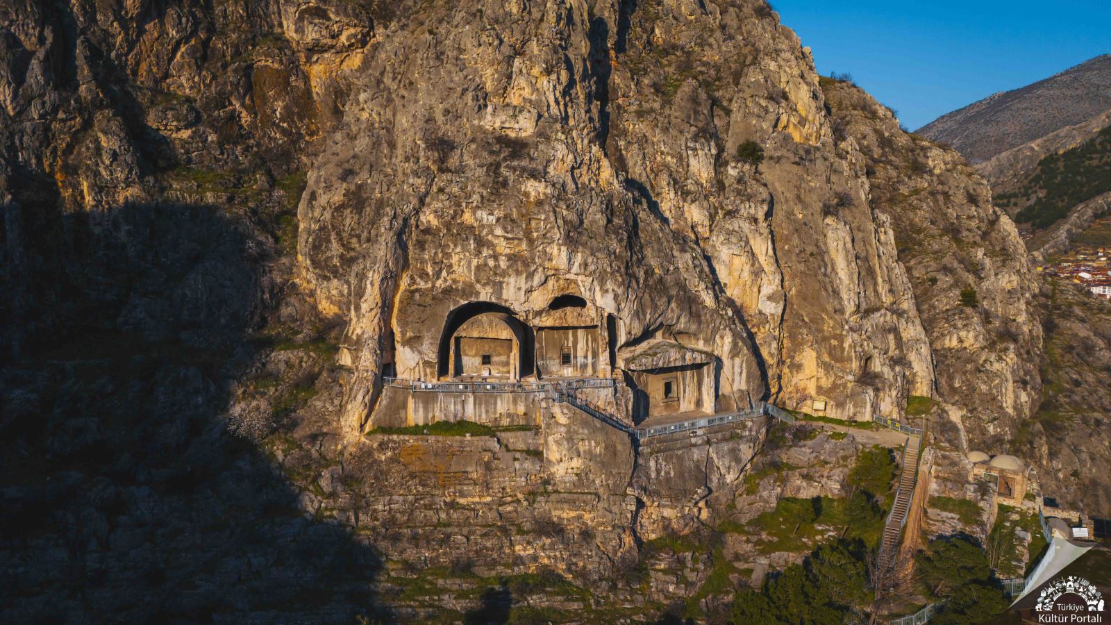
The royal rock-cut tombs above Amasya.
 The Royal Tombs of Pontus
The royal tombs were cut into limestone on the southern slope of Harşena and are associated with the kings of Pontus when Amasya was their capital. The Maiden's Palace area contains five major royal tombs, with rock-cut passages separating parts of their façades from the mountain. Their openings, chambers and elevated positions form deliberate funerary architecture, expressing the city's political standing in the Hellenistic period.
Mount Harşena and the royal tombs entered UNESCO's World Heritage Tentative List in 2015. This is a tentative listing and does not mean inscription on the World Heritage List. Considering the tombs alongside the palace remains and walls reveals the site's layers, with government, defence and burial represented together above the river.
 The Castle and Historical Memory
Amasya Castle stands on Harşena above the city, preserving walls, towers and water infrastructure. Repairs and reuse over successive periods reflect a long history of adapting military architecture to the rock. Its elevation explains its role in overseeing the valley, while cisterns and passages reveal the needs of a stronghold in a difficult-to-reach location.
During the Ottoman period, Amasya was associated with the education of princes and provincial administration, alongside mosques, medreses and civic buildings. The present townscape brings these memories together with the remains of the ancient kingdom and riverside domestic architecture. Neighbouring monuments reveal the city's historical sequence through their relationships with mountain and water.
 Practical Notes
Steps to the tombs and paths around the castle are steeper than the riverside routes and can become slippery in rain. Check access during excavations or restoration and keep to designated paths. Respect inhabited homes when taking photographs, and read site information to distinguish original remains from restored sections.
 Related topics
 - Amasya 2026: Museums, the Bimarhane and Bayezid II Complex
- Merzifon and Gümüşhacıköy 2026: Heritage and Countryside
- Lake Boraboy, Taşova and Suluova 2026: Water and the Plains
- Tokat 2026: The Castle, Gök Medrese, Taşhan and Historic Houses
- Niksar, Erbaa and Reşadiye 2026: Valleys and Heritage
- Zile, Turhal and Pazar 2026: Castles and Ballıca Cave
- Çorum 2026: Hattuşa, Alacahöyük and Hittite Museums
- Kastamonu 2026: Castle, Clock Tower and Museums
- Küre Mountains and Pınarbaşı 2026: Horma Canyon, Valla Canyon and Ilıca Waterfall
Last edited by a moderator: