

- Joined
- Nov 2, 2025
- Messages
- 282
- Reaction score
- 0
- Points
- 16
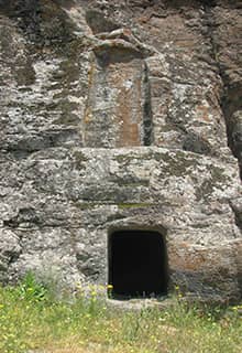
Kayalıdere archaeological site, associated with the kingdom of Urartu.
North-west of Muş, Varto brings together Urartian heritage, mountain scenery and the Hamurpet lakes, also known as Akdoğan. Planning a visit requires a clear distinction between learning about this landscape and entering a protected area. Attractive photographs do not establish that the shores are open for unrestricted walks or camping.
 Varto as a Base for a Focused Outing
Use the district centre to arrange your route and food and obtain local access information. Then choose a heritage stop that can be visited that day. Avoid spreading a few hours across too many villages and sites: travel and the return journey are significant parts of the day. Save the Turkish place names and ask for the exact permitted arrival point, rather than a general direction towards a mountain or village.
 Kayalıdere and Urartian Heritage
Kayalıdere is associated with the reign of the Urartian king Sarduri II. Twentieth-century excavations revealed a fortress, temple, storage facilities, tombs and smaller finds. These remains show a settlement with several functions, extending beyond a single tower on a hill. Check current access arrangements and the condition of the approach with local authorities before setting out.
 Understanding the Archaeological Remains
If entry is available, begin by taking in the site's overall position, then examine the stonework and surviving buildings from permitted areas. Objects shown in excavation photographs will not necessarily remain on site: some finds are displayed at the Museum of Anatolian Civilisations in Ankara. Relate the information to what is visible, and leave stones and pottery fragments where they are.
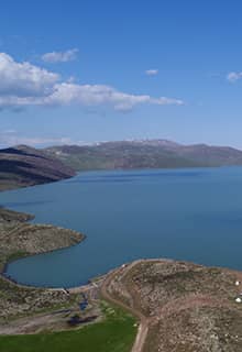
A documentary view of the Hamurpet lakes; the photograph does not establish permission to enter the protected area.
 Two High Lakes with Several Names
Hamurpet lies within Varto district and comprises two freshwater lakes at roughly 2,200 metres. Descriptions commonly distinguish the greener-looking larger lake from the deeper, bluer smaller one. The contrast between water and surrounding rock, together with the mountain setting, gives the area much of its appeal. These details introduce the environment; they do not establish a visitor route.
 Can You Visit Hamurpet?
Akdoğan was registered as a wetland of local importance in 2021. The Ministry of Education visitor page lists visits throughout the week but explicitly prohibits entering the lake water. This does not establish access to every part of the shore, permission to camp or an unrestricted walk around both lakes. Ask the local nature-conservation authorities about current access and any restrictions before arranging a trip that depends on entering this area.
 A Practical Alternative That Respects Access Limits
Spend the day in Varto and at an accessible heritage site, with stops in public places to enjoy mountain views along the route. If the archaeological site cannot be confirmed open, choose a relaxed local outing instead of following an unfamiliar track. Bring water and suitable clothing for cold weather, set a return time, and value the protected landscape without treating its photographs as a guaranteed itinerary.
 Related topics
 - Bulanık and Lake Haçlı 2026: The Plain, Lakeside Scenery and Esenlik Mosque
- Muş and Murat Bridge 2026: The City, Plain and Local Food
- Malazgirt 2026: The Castle, Monument, Museum and the Battle of 1071
- Bingöl by Season 2026: Karlıova Sunrise and Hesarek Skiing
- Bingöl and Buban 2026: City Walk, Heritage and Rock Formations
- Solhan and the Floating Islands 2026: Location, Landscape and Visiting
- Kiğı and Adaklı 2026: Stone Architecture and Bingöl Village Heritage
- Bingöl: A Thousand Lakes and the Mountains of Eastern Türkiye
- Muş: Spring Flowers and Rural Life in Eastern Türkiye
Last edited by a moderator: