

- Joined
- Nov 2, 2025
- Messages
- 282
- Reaction score
- 0
- Points
- 16
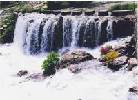
The Munzur springs near Ovacık.
Ovacık and Pülümür share the mountains and rural economy of northern Tunceli, yet each has a distinct landscape. Ovacık lies around a plain crossed by the Munzur, while Pülümür is associated with its narrower river valley and surrounding uplands.
The Pülümür joins the Munzur at Tunceli city. Understanding these two separate river systems helps make sense of the province's geography.
 Ovacık: The Plain and Munzur Springs
Ovacık's plain provides farmland between the mountains. The district administration describes meadows along the Munzur used for grazing and winter fodder. The river rises from springs west of the district centre, emerging from karst rock at the foot of the Munzur Mountains before passing through Ovacık towards Tunceli.
The plain and villages are thus closely connected with a water source whose beginnings can be seen at the springs. The tourism directorate identifies beans among the area's crops, walnuts in the Mercan Valley and some villages, and livestock keeping.
Agriculture is part of Ovacık's identity, with work organised around sowing and collecting fodder as well as the changing seasons.
 Pülümür: The Valley and Uplands
The Pülümür River rises on the slopes of the Avcı Mountains and is fed by snowmelt and numerous tributaries. Steep slopes, woodland, waterfalls and rocky sections surround much of its course, contrasting with Ovacık's broader plain.
Between Kutudere and Kırmızı Köprü, the valley becomes particularly deep, with side waterfalls feeding the river.
Mountainous terrain limits the area available for crops. Livestock keeping and summer grazing on upland pastures play a larger role, and Pülümür is also known for honey supported by varied plant life.
This contrast gives the two neighbouring districts different productive landscapes within northern Tunceli.
 Winter, Water and Rural Work
Ovacık's district administration explains the role of snow as a water resource: spring melting replenishes groundwater and streams. The Pülümür also depends on snowmelt and tributaries.
Water availability, farming and grazing are therefore linked to season and elevation, and both valleys change markedly between spring, summer and winter.
Cold upland winters affect rural work and access to villages. Roads, services and winter fodder stocks have direct economic importance for households alongside water itself.
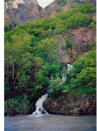
The Pülümür Valley follows a separate river that joins the Munzur at Tunceli.
 Local Life and Protected Nature
Munzur's national park protects woodland, river and mountain habitats. Official descriptions include birch near Ovacık, oak woodland, and animals such as bears and otters.
Natural places also feature in local beliefs. They form part of residents' relationship with the landscape and deserve respect during a visit.
 Local Production and Protecting the Valleys
This geography suggests opportunities in improving the production and marketing of beans, honey and dairy products, alongside services needed by villages in winter. Visitors can support local businesses when the scale and sensitivity of natural sites are respected.
Protecting springs and river channels, managing waste and limiting pressure on pastures all support the rural economy. Healthy water and vegetation sustain livelihoods while preserving the distinct character of each valley.
 Related topics
- Tunceli City 2026: Rivers, Museum and University Life
- Hozat and Nazımiye 2026: Mountain Towns and Rural Heritage
- Refahiye and İliç 2026: Forests, Villages and Local Economy
- Tercan, Çayırlı and Otlukbeli 2026: Plains and Rural Heritage
- Southern Tunceli 2026: Pertek, Mazgirt and Çemişgezek
- Kemaliye and Kemah 2026: Karasu Valley and Local Heritage
- Erzincan and Üzümlü 2026: Plains, Cimin Grapes and Urban Life
- Erzurum: The Historic Capital of Eastern Türkiye
- Elazığ: Lakes and Deep Anatolian Heritage
Last edited by a moderator: