

المسافر
Active member
- Joined
- Dec 3, 2025
- Messages
- 189
- Reaction score
- 0
- Points
- 16
Ulubey Canyon and Blaundus 2026: Reading the Landscape and Protecting Heritage
Ulubey and Blaundus in Uşak Province bring together a landscape of valleys and the remains of ancient settlement. Considering them together helps explain the place: how has water shaped the land, and how did an ancient city make use of a plateau surrounded by valleys? This guide focuses on observation, interpretation and the quality of visitor management. The complementary Ulubey and Blaundus trip guide covers the day's stops and transport arrangements.
The canyon: read the overall shape first
The Uşak Provincial Directorate of Culture and Tourism describes canyons associated with Kazancı Deresi and Banaz Çayı, linking their formation to the geological character of the province's southern and southwestern areas. It treats the canyons and Blaundus as complementary natural and cultural resources.
From a designated viewpoint, compare the canyon rim with the valley floor, and follow the watercourse and any visible bends and slopes. These are visual observations that help you understand the landscape; dating rocks or assigning them to a particular geological formation requires specialist interpretation. Children can sketch a simple outline of the rim and floor and compare it with the view while staying on the path.
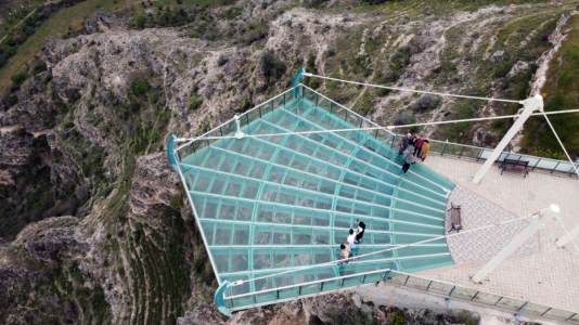
The glass viewing platform overlooking Ulubey Canyon; an original attachment from this topic.
Blaundus: why was this plateau chosen?
The directorate places Blaundus within the boundaries of Sülümenli village in Ulubey district, on a peninsula-like landform surrounded by deep valleys. Its account associates the city's foundation with settlers from Macedonia after Alexander's campaign in Anatolia and notes its growing importance under Roman rule.
Start with the setting before trying to identify every stone: observe how the built area relates to the edges and access routes, then look for signs explaining the remains. The directorate lists structures including fortifications, temples, a theatre, a stadium and rock-cut tombs. Their inclusion in a site description does not mean that all are intact, easily identifiable or accessible at every visit; follow the interpretation and open routes on site.
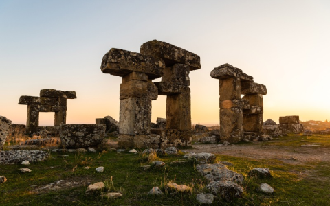
Stone remains at Blaundus; an original attachment from this topic.
Three questions for a more rewarding visit
- What has the natural landscape shaped? Compare the canyon's form with the city's elevated setting, recording what you see without turning an impression into a historical fact.
- What evidence identifies a building's purpose? Use an information panel or a specialist's explanation, distinguishing a documented identification from a guess suggested by the stones' appearance.
- What would help visitors understand more? Note where a map, interpretation or a clear direction sign would be useful; these observations help assess the visitor experience.
Protecting the place is part of understanding it
Stay on permitted routes, leave stones and fragments where they are, and avoid climbing on remains for a photograph. If you notice an interesting feature, photograph it from an allowed position and ask site staff about it. Near canyon edges, use designated viewpoints and leave room for other visitors. These are suggestions for responsible visiting and should be followed alongside the site's own instructions.
How should destination improvements be assessed?
Four useful criteria are clear information, management of visitor movement, protection of the landscape and archaeological remains, and benefits for the local community. Simple maps and good interpretation help explain the site, while facilities need suitable locations that do not obstruct views or put pressure on the remains. Guiding and local products can add value when organised with respect for the place.
When reading a development announcement, distinguish a proposed project from completed work and a service that is actually operating. Some official overview pages contain older proposals, so they should not be used alone as evidence that a service is running in 2026. Confirm the current position with the responsible organisation before relying on it for your visit.
 Related topics
- Kula and Salihli: Geopark and Nature
- Sardis and Bin Tepe: Lydian Heritage
- Aydın and Denizli Heritage Route
- Fethiye, Ölüdeniz and Seydikemer
- Didim, Söke and Lake Bafa
- Northern İzmir: Industry, Coast and Heritage
- Manisa: Towns, Economy and Services
- Gediz Valley: Water, Grapes and Olives
- Selçuk, Ephesus and Şirince
Last edited by a moderator: