

المسافر
Active member
- Joined
- Dec 3, 2025
- Messages
- 189
- Reaction score
- 0
- Points
- 16
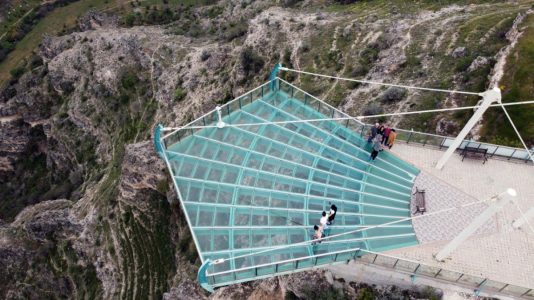
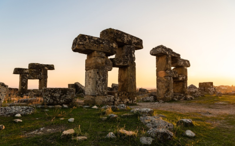
Ulubey Canyon and Blaundus 2026: Landscapes and an Ancient City
Uşak province offers the opportunity to combine views of Ulubey Canyon with the ruins of Blaundus in a well-planned trip. Each provides a different experience: the scale and contours of the canyon landscape, followed by an ancient city built on high ground surrounded by steep slopes.
Depending on your starting point and transport, you could visit both in a dedicated day or allow two days for unhurried photography and walking. Mark both entrances on your map and arrange your return journey before setting out.
Ulubey: start with the landscape
Ulubey has a network of valleys and slopes shaped by watercourses, with a glass viewing platform overlooking the canyon. Official visitor information also describes ancient water channels, rock-cut tombs and caves in the area.
Begin by observing the terrain, the direction of the watercourse and changes in elevation. Take in a broad view before concentrating on individual details, staying in designated visitor areas.
For children, the visit can introduce the relationship between water, landforms and human settlement through what they can see, without complicated geological terminology.
A viewpoint and a canyon walk are different outings
Easy access to a viewpoint does not establish that a route descending into the canyon is equally straightforward. Before choosing a walk, ask about its course, length, elevation changes and finishing point, and whether it suits everyone in your group.
If you mainly want views and photographs, allow time for those activities and a break. Make a longer walk the main activity of the day, with water and equipment appropriate to its duration and the weather.
Consider the whole group's abilities. A comfortable short outing may work better than a longer programme that some participants need to abandon early.
Blaundus: understanding the relationship between a city and its terrain
Blaundus stands on high ground surrounded by steep-sided valleys. Its origins are associated with Hellenistic settlement by people from Macedonia after Alexander's campaigns; it later came under the Kingdom of Pergamon and Roman rule.
Visitor accounts describe a gateway, sections of defensive walls, and religious and sporting buildings. Two questions provide a useful introduction: how did the city use the advantages of its terrain, and how were its functions arranged within the space available?
This approach helps make sense of the ruins even where buildings are incomplete or difficult to identify. Use site panels or available interpretation to develop your understanding, and respect conservation and excavation areas.
A suggested day from Uşak
First part of the day: Check the weather and visiting arrangements before departure, then visit the Ulubey viewpoint for the landscape and photography. Choose a time that suits the light and the group's comfort, without making the day depend on a narrow photographic window.
Midday: Take a food and water break, then travel to the second destination. Arrange supplies before leaving the service centre, particularly if you intend to spend considerable time at the archaeological site.
Later: Explore Blaundus, allowing time to understand the setting and buildings. Decide your return time before becoming absorbed in photography and leave a margin for travelling back to your accommodation.
Reverse the order if your starting point, the weather or opening arrangements make that more practical. If a full day is unsuitable for someone in the family, visit one site and leave the other for a separate trip.
Getting there and back
If using public transport to a nearby town, check the remaining journey to the attraction's entrance. A destination name in an advertisement or transport app may mean the town centre, with a further transfer required to reach the site.
When arranging a driver, agree on both locations, waiting time and the meeting point. If driving, save routes and addresses beforehand and follow local signs where they differ from an app's suggestion, particularly near archaeological sites and unsurfaced or undeveloped routes.
Timing and photography
Light, cloud and wind affect visits to open viewpoints and ruins. Check the forecast for your visit and plan clothing, water and rest time accordingly.
Photograph from designated viewing areas and leave room for others to pass. Good views do not require approaching cliff edges or climbing archaeological remains. Extra time to explore and observe is often more rewarding than fitting too many stops into one day.
What would improve the visitor experience?
Destination development can be assessed through clear access and signs, good interpretation of history and nature, basic facilities, organised visitor movement, and protection against litter and inappropriate alterations to the landscape.
Useful improvements could include information connecting both sites with Uşak city, explaining visiting times and the difficulty of walking routes. Nearby villages could benefit from guiding and local products where these services are organised in ways that preserve the area's character.
These are suggested standards for improving the experience, rather than a list of new projects completed in 2026. When reading a development announcement, distinguish completed work from proposals.
Before returning
Collect your belongings and litter, and confirm the meeting point if travelling with a group. If you have time to spare, note the places you enjoyed and routes worth a longer future visit, rather than rushing to add a distant stop. Your first trip can then form the basis for a deeper exploration of Uşak and its surroundings.
 Related topics
- Kula and Salihli: Geopark and Nature
- Sardis and Bin Tepe: Lydian Heritage
- Aydın and Denizli Heritage Route
- Fethiye, Ölüdeniz and Seydikemer
- Didim, Söke and Lake Bafa
- Northern İzmir: Industry, Coast and Heritage
- Manisa: Towns, Economy and Services
- Gediz Valley: Water, Grapes and Olives
- Selçuk, Ephesus and Şirince
Last edited by a moderator: