

- Joined
- Nov 2, 2025
- Messages
- 282
- Reaction score
- 0
- Points
- 16

Mount Ağrı (Ararat), with its snow-capped summit reflected in the water and reeds in the foreground.
This part of Ağrı brings together Mount Ağrı, known as Ararat, and highland Lake Balık. The mountain dominates a broad horizon; the lake offers a closer landscape of water, pasture and surrounding village life.
Treat them as separate visits according to your accommodation and travelling time. Begin with a clear aim: a suitable mountain viewpoint, time beside the lake or a specialist outdoor activity.
 The Mountain That Defines the Horizon
Mount Ağrı is Türkiye's highest mountain, approximately 5,137 metres high. Its immense mass makes it a regional landmark, but the view and visibility of the summit vary with your position, clouds and light.
Choose a readily accessible viewpoint and allow time to stop instead of relying on a photograph from a moving car. Observing the mountain and surrounding terrain is a complete experience in itself.
 The National Park and Its Varied Habitats
Mount Ağrı National Park was designated in 2004 and extends across parts of Doğubayazıt, Aralık and Karakoyunlu districts. Its vegetation ranges from steppe and grassland to higher-altitude plant communities, according to elevation and terrain.
Notice changes in vegetation and ground between the lower and higher areas. Choose an activity suited to the available route and your experience.
 Sightseeing and Specialist Mountain Activities
A sightseeing and photography outing differs from a long mountain walk or specialist ascent. Decide what you want before booking. If your plan goes beyond ordinary visitor locations, check current arrangements and requirements with a qualified provider.
For a relaxed outing, bring water and clothing suitable for wind, agreeing your return arrangements in advance. For longer routes, assess the terrain, weather and your experience before setting out.
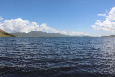
Lake Balık amid Ağrı's uplands and surrounding pasture.
 Lake Balık and Its Origins
Lake Balık lies in high country between Taşlıçay and Doğubayazıt. It is described as a lake formed behind a lava barrier, an origin that helps explain its form and position within the surrounding terrain.
At approximately 2,241 metres above sea level, the lake connects with pasture and the rural life around it. Spend time viewing the shore from a suitable position, taking photographs and observing the transition between water and upland ground.
 Water, Birds and Villages
The lake is important to local water supplies and provides habitat for birds. A quiet visit respects it as a natural resource connected with nearby villages, alongside its appeal for scenery and photography.
For birdwatching, bring binoculars and observe from a suitable distance without disturbance. Add a village or nearby market stop if you wish, respecting pasture and property boundaries.
 Dividing a Day in Nature
Choose one destination as the day's focus, allowing time for short walks, meals and pauses. If combining both, calculate actual travelling time so that enough remains to enjoy the landscape.
Check weather and roads, save key locations on your phone, and agree return arrangements before the outing. Leave shores and viewing paths as you found them.
 Related topics
- Doğubayazıt and İshak Paşa Palace 2026: Historic Architecture and Heritage
- Diyadin 2026: Hot Springs and the Canyon
- Iğdır 2026: Aras Plain, Farming, Markets and Daily Life
- Ağrı, Eleşkirt and Patnos 2026: City Life and the Plains
- The Aras Wetlands in Iğdır 2026: Birds, Nature and Field Research
- Karakoyunlu and Aralık 2026: Iğdır Plain Heritage and Village Life
- Tuzluca 2026: Salt Caves, Rainbow Hills and District Landscapes
- Erzurum: The Historic Capital of Eastern Türkiye
- Van: The Pearl of the East and Its Legendary Lake
Last edited by a moderator: